Showing posts with label Middle Road Turnpike. Show all posts

27 December 2013

Milestone XVII


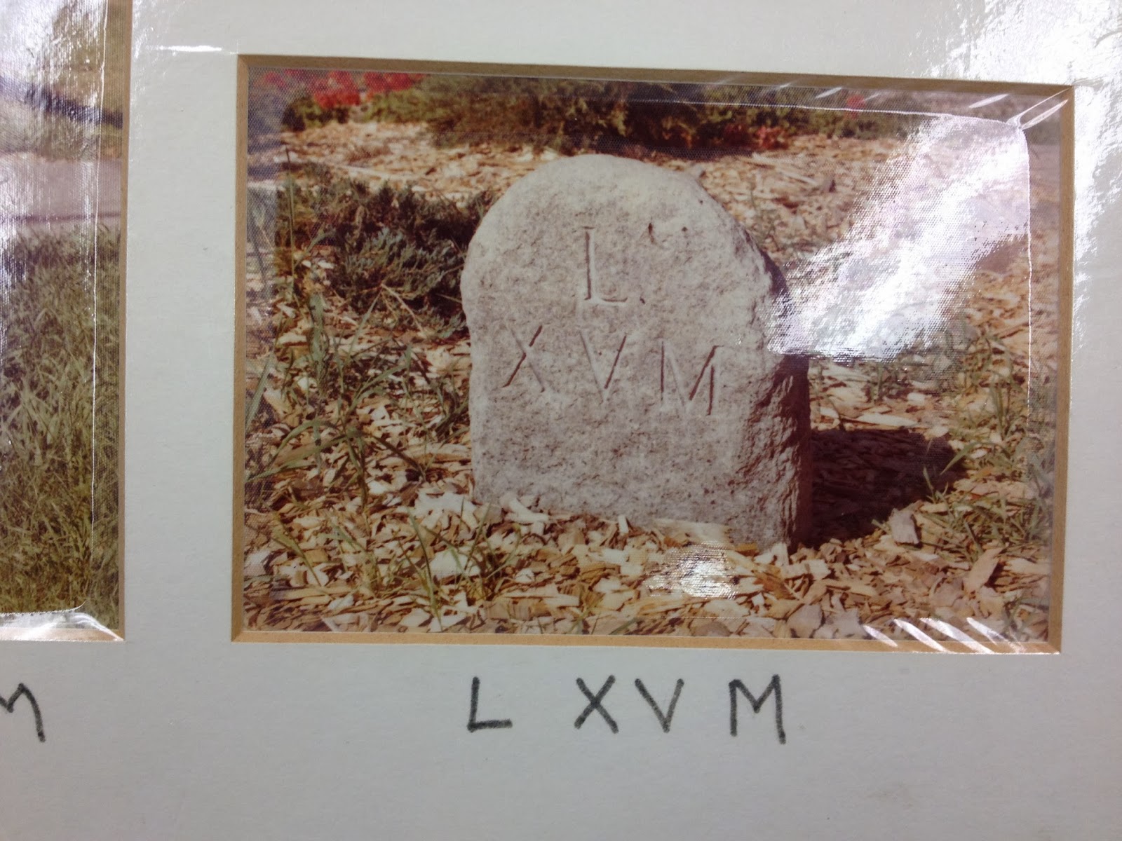
The most southerly of Woodbury’s Benjamin Franklin Milestones lies about 200 feet north of the Southbury / Woodbury town line, part of the stone wall in front of Longwood Inn (formerly Merryvale), a restaurant and bed & breakfast for many years. Its plaque is affixed to the adjacent stone wall.
Sage (1932) observed that the entire stone had been “whitened with paint or otherwise.” By the time of the Bicentennial survey and my current photographs, the whitened surface had returned to a natural stone finish. The lettering style differs from most of the other stones in the series, using three lines: “L”, “XVII”, and “M”. The layout and chiseling appears the same in each of the three photos, supporting the assumption that this is the original inscription. 

Sage (1922)


Although a fracture line (between the second and third line) is visible in the 1976 and 2013 photos, the stonewall encapsulating the milestone seems to be protecting it from collapse. The bubbles seen in the Bicentennial photo are the effect of the plastic overlay and do not represent any alteration of the stone. The inscription remains clearly visible.


Bicentennial Report (1976)

Hampton (2013)


Lat: N 41° 30.565'
Long: W 073° 12.376'

Heading north towards Litchfield, you welcome the town line marker and Milestone XVII, signaling your arrival in the mother town of Litchfield County, having passed mile after mile of lonely woodlands and farms in the sparsely settled Southbury and Oxford. Here you will find stores, businesses, and the first true inn you’ve seen for several days, the Curtis House. Perhaps the blacksmith can attend to your horse’s loose shoe before disaster strikes. You should arrive at Tapping Reeve’s Law School tomorrow, to begin your training. If you report favorably about this country village, your sister hopes to become a student at the Litchfield Female Academy.
In just over a year’s time, you’ll take an examination to be admitted to the bar of Litchfield County, but you’re looking forward to a triumphant southerly trip to your home state as an attorney-at-law! Of course, you’ll have to take an additional bar examination at home, but with your letter of reference from Judge Tapping Reeve, the legal world is your oyster.

26 December 2013

Milestone XVI


Sage (1922)


Bicentennial Report (1976)

Hampton (2013)


For many years, this corner of the ellipsis formed by Main Street South and South Pomperaug Avenue has been better known as the location of the Milestone Motel (now the Milestone Inn) than as the location of Milestone XVI. With traffic passing within a few feet of either side of it, it remains in remarkably good condition, although the metal signpost is all that remains of the “Benjamin Franklin Milestone” plaque. The chiseled lines “L” and “XVI M” are still quite legible.

As with many of the stones in this series, the surround level of the earth has been gradually raised so that the lower line is now at ground level, near the edge of parking spots for Joey's Deli, putting the milestone at risk of fracture or dislocation from impacts by cars, trucks, and snowplows. As of this week, it emerged from the piles of snow cleared from the parking area, apparently still standing.

Lat: N 41° 31.395'
Long: W 073° 12.150'

Milestone XV


Located at the original site of the meeting hall built by the first European settlers in the 1600's, this milestone is near what is now known as the South Green and Soldiers Monument. The Meeting House for the Congregationalists was the first building, more closely resembling a fort than the popular image of a white colonial New England church. It was used for governmental operations (Congregationalism being the established church at the time) and as a defensible stronghold (although no battles were recorded there). When a new church building was being planned around the turn of the nineteenth century, a dispute arose about its location. Those favoring a more northerly location eventually split from the original church and formed the “Strict Congregational Church”, today known as the North Congregational Church. That church sits at the corner of Rtes. 6 (Main Street North) and 47 (Washington Road), at the location of Milestone XIV. Eventually, the "new" First Congregational Church was built halfway between the two milestones.


Sage (1922)

Bicentennial Report (1976)

Hampton (2013)
A comparison of the Sage (1922) photo of Milestone XV with the Bicentennial photo and the current day appearance of the milestone strongly suggests that the stone we see today has been recut (possibly by machine) with the appropriate markings to correct what Sage (1932) described as “so weather beaten that none of the original inscriptions appears.” The over shape of the stone in each picture seems to match, so this seems to be the original stone. Sage describes the white lettering shown in his photograph as “paint recently applied . . . which may account for the “M” being below the XV, instead of on a line with the number, as is the case in the originals.”
To the West of this milestone is the Hurd House and to the East, District No. 2 Schoolhouse, two historic buildings maintained by the Old Woodbury Historical Society.

Lat: N 41° 32.254'
Long: W 073° 12.426'